Skip to Main Content

Support Freight Planning

Enhance planning capabilities with reliable data insights for transportation planners.

Stay ahead of the curve

Transportation planners are required to keep freight plans updated and comprehensive. Maintaining efficiency and compliance is challenging, especially when dealing with data gaps and confidentiality concerns. That’s why we provide detailed freight insights with secure data processing, helping you get reliable and granular information to make informed planning decisions from.

Accomplish national freight strategic objectives

Drive better outcomes from your planning efforts without worrying about the quality of data sources or finding the insights needed for improved results.

Keep your freight plans current and effective with modeled AADT counts. Additionally, Expansion Factors gives you accurate and comprehensive market-representative road volume figures for reliable planning.

Drive informed economic planning with detailed data on goods traffic. The Regional Travel Metrics module provides essential metrics on vehicle characteristics, travel volume by industry to support economic planning and policy-making.

Streamline freight movement by analyzing routes and commodity flows with metrics on journey counts, vehicle breakdowns and travel times. Route Analytics enhances logistics operations, reducing costs and improving service delivery.

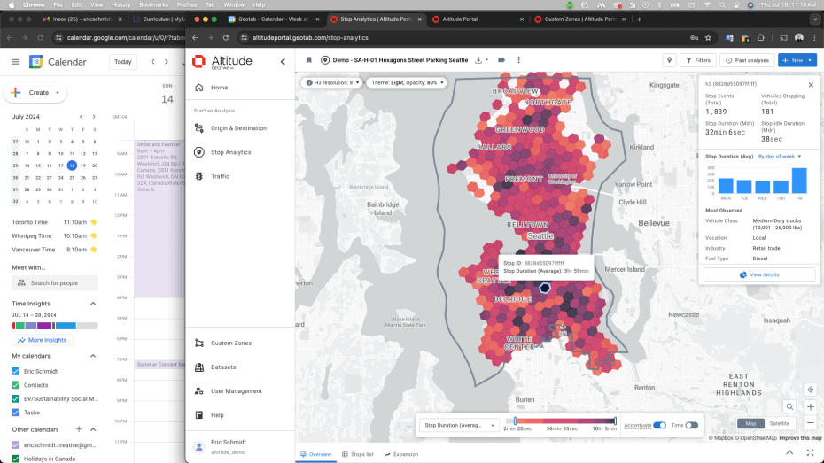
Understand the importance of infrastructure to freight movement by analyzing usage, which enables better planning for the maintenance of bridges, highway segments, rest stops and other critical infrastructure. The Stop Analytics Module provides detailed freight stop data and trends to help pinpoint high-use locations.

Enhance the safety of all road users by building secure and reliable rest locations for truck drivers along their routes. The Stop Analytics Module identifies frequently used parking areas, while the Traffic Analytics Module enables targeted interventions for safer roadways.

Keep your plan up to date with Altitude

Leverage reliable freight movement insights in a powerful set of tools designed to enhance your ability to develop and maintain an effective freight plan.

Origin & Destination Module

With the ability to create full journeys by chaining trips together over multiple duty cycles, understand true origins and destinations to better manage the movement of goods. Uncover the context behind journeys with detailed insights into commercial vehicle movements, reporting on vocation, class and industry.

Route Analytics

Analyze routes between origin and destination pairs to gain metrics such as journey counts, vehicle breakdowns and travel times. Quantify the relative importance of different infrastructure elements used to support freight movement. Route Analytics provides detailed insights for all commonly used routes.

Traffic Analytics Module

Understand traffic patterns per road segment, including interstate highways, major arterials, connectors and more. The Traffic Analytics module offers critical traffic-related information for safer road design and efficient freight movement, helping transportation planners optimize routes and achieve compliance.

Stop Analytics Module

Gain insights into heavy-truck parking patterns to inform freight parking plans. This module provides a comprehensive understanding of where and why vehicles are stopping, enabling stronger planning.

Regional Travel Metrics Module

Gain insights into basic vehicle characteristics and the observed vehicle distances traveled within a specific geography. This module provides essential metrics for regional travel analysis, such as AADT (Annual Average Daily Traffic), aiding in comprehensive regional planning and infrastructure management.

Expansion Factors

See beyond trip data to breakdown traffic volume with context into market-representative heavy, medium and all commercial and non-commercial vehicles for Motorway, Primary, Secondary, Tertiary and Trunk road segments. Improve transportation planning precision and project management using accurate expansion factor data.

About the Altitude platform

Altitude by Geotab provides reliable and contextualized mobility insights for public and commercial sector decision-makers to gain a complete understanding of movements across road networks.

This enables our customers to achieve improved planning capabilities as well as better financial outcomes, without the challenge of finding trustworthy and usable data sets.

As the primary source and processor of mobility data, we prioritize complete confidentiality and privacy while maintaining the full context of vehicle movements.

Altitude elevates freight planning

Experience comprehensive freight planning with contextualized mobility insights. Book a demo to discover how you can achieve seamless compliance and improved efficiency.

Frequently Asked Questions

A: We are the primary source of data, collected from commercial fleet vehicles through Geotab. To understand how Geotab’s data relates to the entire market, we also integrate ground-source truth data from FHWA’s HPMS AADT data and counting stations. As the data source, we prioritize accuracy and integrity, with the ability to add additional context such as vocation, vehicle type and class, fuel type and even industry, providing more granularity. We do this in a way that protects privacy and confidentiality, which keeps our information always safe to use.

A: We take data privacy and confidentiality extremely seriously by using stringent anonymization processes, secure transmission protocols and maintaining compliance with all relevant data protection regulations. Our measures include data encryption, access controls, ongoing employee training, anonymization of personal identifiers and regular audits. Additionally, we use the patented PI Safe layer, enhancing our data protection framework to keep information safe while providing more granular insights. Learn more about our commitment to data privacy here.

A: Because we are the source of vehicle data, we can aggregate and analyze complete vehicle history. Altitude provides detailed vehicle data including vehicle types, classes, vocations, trip histories and more. This additional context helps transportation planners make informed decisions and develop effective freight plans.

A: The accuracy of our data is validated through high-frequency GPS sampling, advanced algorithms and rigorous validation processes, including checks against publicly available ground-source truth stations. Our transparent processes are crucial for verifying reliability and trustworthiness, making our data highly capable for use cases such as traffic flow, route optimization and fleet management studies.

A: Altitude provides filtering, visualization and insights within the platform. If you want to export the data for use with other platforms, you can do so, or use the API to connect Altitude insights to another platform of your choice.