New Study Reveals State-by-State Safety Benchmarks: Altitude by Geotab Presents Insights at TRB 2025
Learn about Geotab ITS’ rebrand to Altitude by Geotab and view our Digital Privacy white paper.

Altitude by Geotab recently published “Bridging the Data Gap: Commercial Insights from Five Key U.S. Bridges” to understand the potential impact and far-reaching effects of several different bridge shutdowns on surrounding regions. Our team studied transportation analytics from multiple major metropolitan areas to assess the traffic flow on these bridges and how regional resiliency, roadway safety and movement efficiency would all fare if a closure were to occur. From our ebook, here are two of the most noteworthy stories we uncovered about the importance of infrastructure and transportation resiliency with the help of mobility insights.
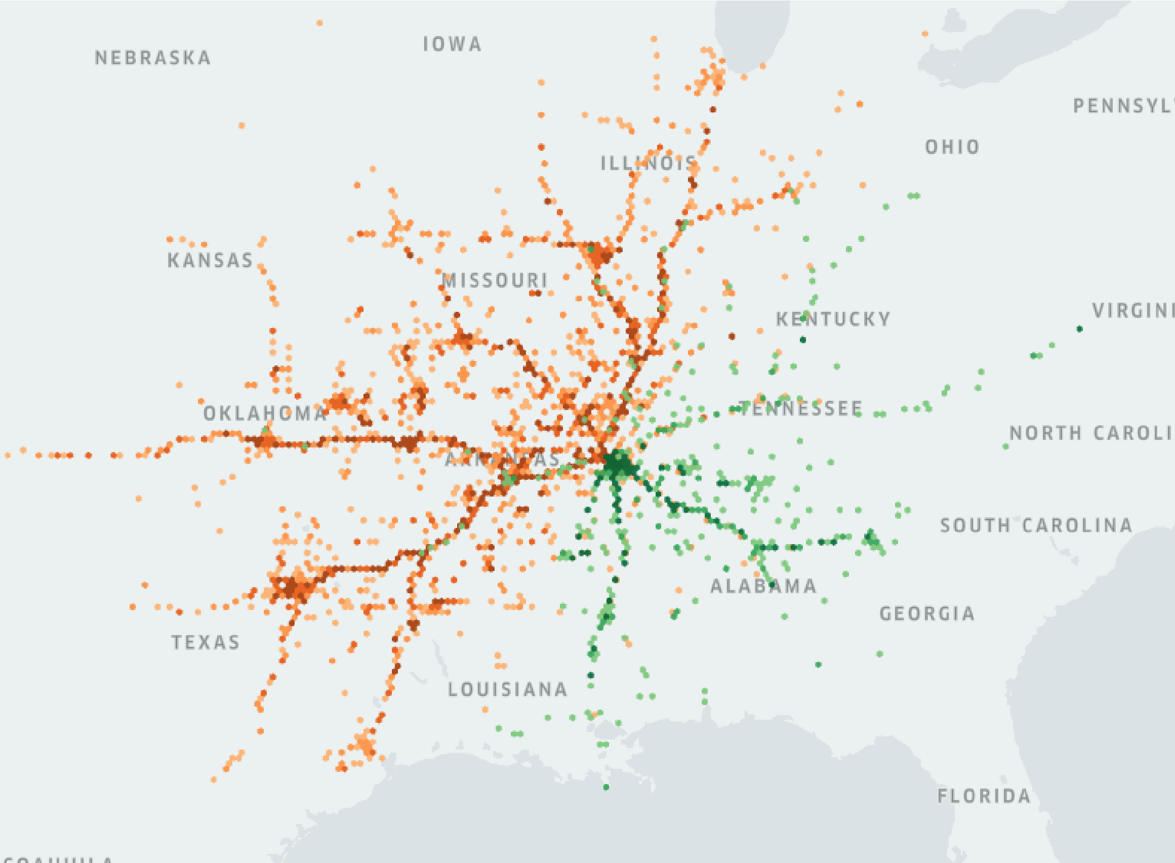
Across the Tennessee/Arkansas border lies two major bridges, the Memphis-Arkansas Bridge and the Hernando de Soto Bridge, which are viewed as major thoroughfares that are critical for long-haul commercial vehicle movement for the region. In June of 2024, the Memphis-Arkansas Bridge experienced a two-week closure for construction maintenance. A longer-term closure is planned for 2026. Our findings after reviewing the closure-specific data gave us confidence that while traffic and regional supply chains would be affected by the impending shutdown, if transportation agencies were to leverage traffic insights to build a mitigation plan in advance, their regions would be prepared to minimize resulting safety and goods movement delays. Here were some of the standout takeaways we found:

Test 123 caption
Origin and Destination insights showing the potential impacts of the Hernando de Soto Bridge closure. Green hexagons indicate the stopping points of vehicles going over the bridge from TN into AR and orange hexagons indicate the end points of vehicles crossing it from AR into or through TN.
By leveraging insights like these, transportation planners and engineers can justify creating new policies or roads to accommodate major construction projects or bridge closures, while also limiting safety issues and supply chain consequences.
The Ambassador Bridge extends from Detroit, Michigan to Windsor, Ontario and is a vital conduit for both the U.S. and Canada’s manufacturing industries. Beginning on February 7, 2022, a protest ended up obstructing traffic across the bridge for six days, with a total blockade occurring over the course of four. Due to the shutdown, there was roughly a 56% decrease in average daily journeys recorded by commercial vehicles traveling between the southern tip of Ontario and Michigan.
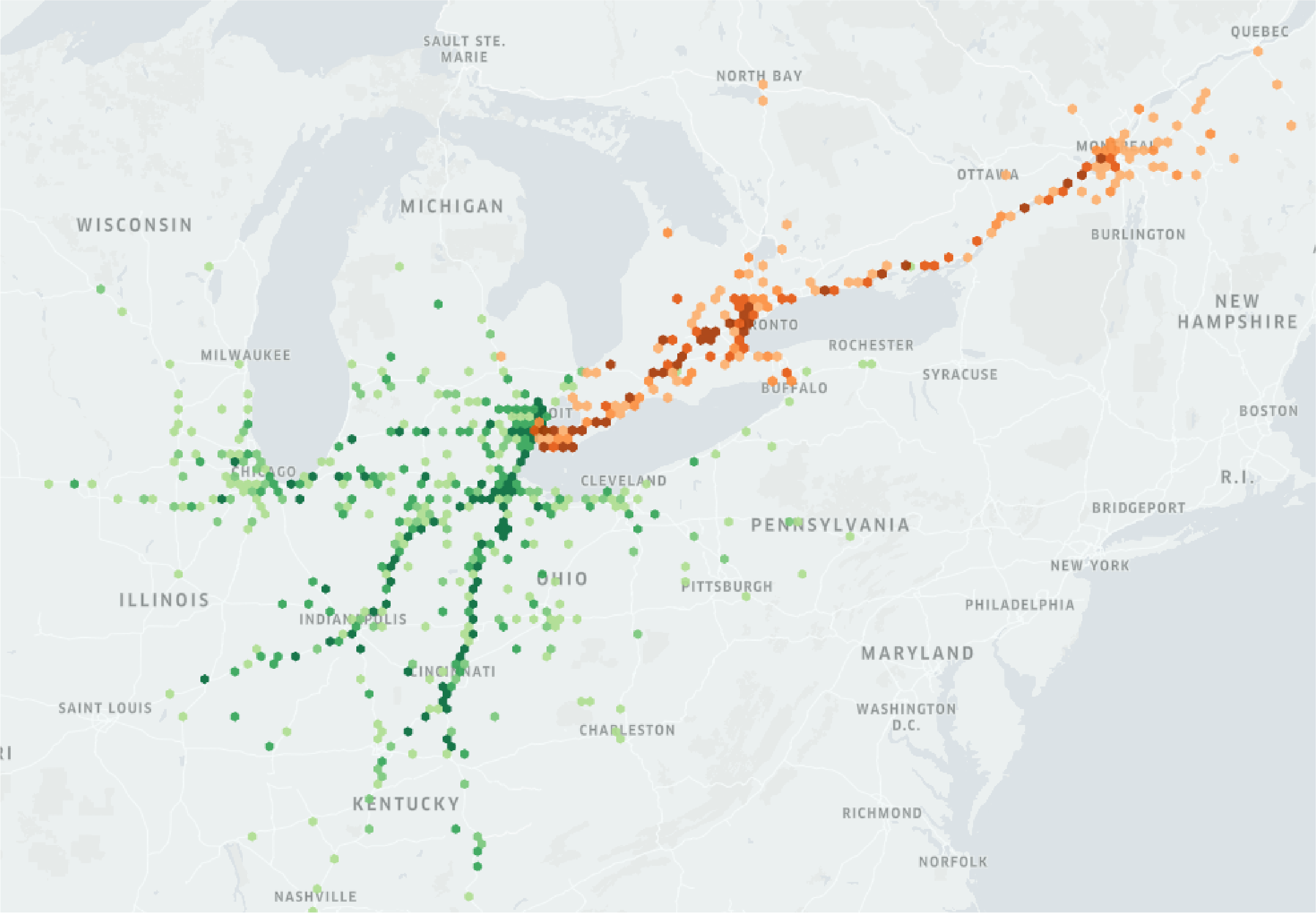
In our study, we hypothesized that the dip in journey counts was because many drivers chose to avoid the bridge’s surrounding area during the blockade. As a result of the traffic disruption, our Origin and Destination insights showed that impacts were felt as far north as Montreal, particularly for long-haul drivers. Commercial vehicles were found to have most commonly rerouted up and around through Sarnia, Ontario to reach their destinations during the closure.

An Origin and Destination map indicating how far-reaching the impacts of the Ambassador Bridge shutdown extended. Orange hexagons indicate trips starting in Michigan and green hexagons indicate the destinations of trips starting in Windsor.
Given the ramifications of a closure like this, transportation resilience plans need to factor in more than just local traffic if a shutdown occurs. For long-haul heavy regions, understanding how a potential bridge closure could impact drivers’ ability to maintain Hours-of-Service compliance must also be planned for and addressed with targeted policies.
To learn more about these engaging stories and all the other deep transportation insights we surfaced in our bridge analyses, read the eBook here.
Resiliency is synonymous with the future of transportation. The supply chains that are responsible for powering our cities and regions must be constructed to withstand the rigors of unpredictable events, both now and in the coming decades. It’s critical for North American transportation infrastructure to be resilient because of how reliant 21st century life is on our road networks. From moving goods and resources to enabling commuters to get to work, any kind of disruption can have far-reaching impacts on economies and livelihoods. That’s why there must be both policies and adequate planning of alternate roads in place to help regions withstand transportation disturbances that arise. As a result of improving the grid, these core benefits can be realized:
Safety – Keeping riders and drivers safer on North American roads starts with identifying the most problematic areas in the grid using CMV data. These insights can help planners and policymakers determine the most dangerous or high-traffic interchanges. They can then develop new strategies around loosening traffic, preventing multi-lane merging or maximizing available space to improve road safety. This process is a crucial part of an effective transportation resiliency plan because it factors in both the seen and unseen factors that may be contributing to excessive road-related injuries or deaths. Mitigating catastrophic outcomes like these with smarter planning helps a region’s transportation network work more effectively for all who travel on it.
Efficiency – Routinely being stuck in vehicle congestion can have disastrous effects on productivity, individuals’ mental health and the environment. Given these harmful and sometimes chronic factors, it’s essential for transportation planners to aim their strategies toward streamlining efficiency too. Offering more route options by building new roads or intelligently redirecting certain traffic flows can help travelers reach their destinations quicker, resulting in happier, more efficient drivers. Unnecessary fuel burn from excessive idling is also reduced, improving air quality. Resiliently planned transportation networks help maintain travel efficiency by actively anticipating possible future increases in vehicle traffic. By building networks in advance to handle population growth, there will be less of a need to redo construction in the future, which costs money and delays commuters even more.
Sustainability – Resilient transportation additionally places a keen emphasis on sustainability. In the context of transportation grids, sustainability usually means two things: Infrastructure that is equipped to handle more electric vehicles (EVs) and reducing carbon emissions by internal combustion engine (ICE) vehicles. Thankfully, with data-driven planning, both problems can be tackled at the same time.
As more and more EVs find themselves on the road, the number of public charging stations needs to increase. Siting optimal locations for new EV charging stations with CMV data assists commercial organizations in their fleet electrification journeys, giving them confidence that a potential shift to EVs would work. More EV charging options in strategic corridor locations can counteract decision-makers’ possible concerns about EV ranges or efficiency, making them more receptive to the idea of an electric fleet. Relying on renewable energy can additionally benefit both companies and the citizens of a region by purifying the air and reducing fuel prices. While new EV charging stations are being built, aforementioned traffic-easing strategies can be implemented to reduce harmful idling by ICE vehicles. Approaching sustainability from both a traffic and an EV charging perspective is key for building better transportation systems.
Fairness – Equitable transportation systems that work for everyone must also be constructed for greater resilience. This is done by improving access to quality transportation and constructing new grid elements fairly across every part of a region. Prioritizing equity when planning new transportation infrastructure prevents underserved areas from becoming neglected during the process, ensuring every individual in a region has equal mobility freedom. With a just and nondiscriminatory approach to transportation planning, the infrastructure of the future can be realized, where efficient road networks are suitable, safer and more accessible for all.
Durability – Infrastructure’s physical strength is the final element of a resilient transportation network. To assess durability needs, planners can use a detailed understanding of a region’s average vehicle volumes, the types of vehicles being driven and common weather patterns when forming their construction strategies. Factors like these all help agencies visualize what types of challenges the bridge, street or highway being constructed will likely need to be able to support (or tolerate). Planners are increasingly using data to identify potential issues in advance and build new infrastructure that is more self-sufficient, requires less maintenance and is able to withstand stronger external threats. By improving infrastructure durability, supply chains are more elastic and regional movement remains uninterrupted.
At Altitude by Geotab, we understand how critical transportation infrastructure is to regional economies and North American life at large. We’ve made it our mission to help organizations devise more effective infrastructure and policies by supplying comprehensive transportation insights they can count on during each step of their planning processes. By implementing data-driven strategies, states, provinces and regions are empowered to enhance their road networks’ resilience and help vehicles move in smarter, safer ways.
Learn more about our contextualized traffic insights and how they can help you make more informed infrastructure and policy decisions by contacting us today.