New Study Reveals State-by-State Safety Benchmarks: Altitude by Geotab Presents Insights at TRB 2025
Learn about Geotab ITS’ rebrand to Altitude by Geotab and view our Digital Privacy white paper.

Never be restricted to pre-defined geographic boundaries or zones for your parking analysis again with the new Stop Cluster feature in the Altitude platform. Users no longer need to restrict their search for parking hotspots or stopping points using the map’s predefined shapes and sizes of geography zones. The Stop Analytics module allows you to identify stops by road segment, zone, hex cell, and now by clustering with the Stop Cluster feature.
Remove the limits of your parking analysis to quickly generate polygon bounds of stopping areas that even include varying stop densities or shape distributions like stops along a stretch of highway or in a parking lot that wraps around a building.
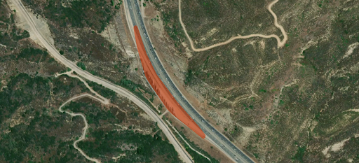
The Stop Cluster analysis can show where commercial vehicles are stopping along highway networks and group the entire parking area as one stop cluster
Transportation planning authorities require commercial vehicle parking insights to make informed parking management decisions. With the Stop Cluster feature, users get the most accurate customer reporting and benchmarking of where commercial vehicles stop and park. This information aids in several real-world planning scenarios, including:
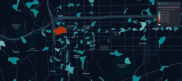
Looking at the stop cluster patterns and stop durations of commercial vehicles in Pasadena can help pinpoint where electric vehicle charging infrastructure should be prioritized
The new Stop Cluster feature means greater granularity in your analysis and captures vehicle stops that may have been missed.
For more information about the Stop Analytics module available in the Altitude platform, visit our webpage. Or, if you’re new to Altitude by Geotab, contact one of our Altitude specialists to schedule a demo.
Learn about Geotab ITS’ rebrand to Altitude by Geotab and view our Digital Privacy white paper.
Discover how factors like city size and temperature influence the idling and stopping patterns of delivery vehicles. Altitude by Geotab’s recent blog post dives into the data from six major cities, revealing interesting findings about door-to-door vehicle tendencies.